Sandown to Ryde (Coastal Path)
12.2 MILES | 6 HOURS
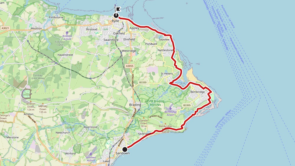
START
A At the pier, walk along the Esplanade, and continue along towards Yaverland and the white cliffs of Culver Down. Walk past the Isle of Wight Zoo, continue through the public car park at Yaverland beach and follow the blue coastal path sign to Culver Down (SS43), to the right of Yaverland Sailing Club. Continue past the holiday centre and through the gate, away from the cliff edge, to follow the ascending path that leads to the monument on the top of Bembridge Down (NT) and ascend towards the monument on top of Culver Cliff.
B Go through the gate at the summit, across the road that leads to an inn and car park, through the swing gate and pass diagonally across the field, right of the large monument to the Earl of Yarborough. Walk through the gap in the corner of the field, and then down a steep chalk path to a stile into a wooded area leading to Whitecliff Bay. Pass several chalets and footbridges. Continue past the steps which lead to the beach along the cliff top to a white footbridge. Follow the path beyond.
Following the blue coastal path signposts through the wooded section, continue along the edge of the old school playing fields and through to another wooded path.
C Continue along the cliff path, ast the edge of Foreland Fields and through a small car park with steps to the narrow coastal path (BB10, towards Bembridge Point), to the seaward side of two large houses, then turn left into the car park of the Crab and Lobster pub, then right past the Coastguard Lookout and bear inland to meet Beachfield Road. Walk along road and turn right at the end (signposted as coastal path), through a modern estate and take the second road off the left, along Forelands Farm Lane.
After about 50 metres (55 yards) turn right along the footpath. Go through the metal barrier at the end of the path, straight ahead past the entrance to the Bembridge Coast Hotel and walk along the Fishermans Walk above the beach to the lifeboat station and car park.
D Continue past the Lifeboat Pier and cafe and along the seawall to the end. Walk along the shoreline to Bembridge Harbour. Alternatively- and if the tide is high, bear left to take the path above the beach, turning left at the junction with 886 (and more steps to beach). Turn right at the postbox and follow 8835 to Love Lane, Walk along the Lane until it bears left, then immediately on your right take footpath 885 to Ducie Avenue and 8embridge Point to emerge at the Harbour.
Follow the main road clockwise around the edge of the sheltered harbour, passing several small boatyards, to the bridge that crosses the River Yar.
E Turn right just past the sign into St Helens, along Latimer Road, turning right again at the corner into North Quay and follow round to St Helens Mill, now a private residence. Keep to the harbour side of this and look out for an enamelled footpath sign indicating the route along the old Mill Dam Wall.
At the end of the wall, walk straight on across The Duver until a tarmac roadway is met. Turn left along the road and pass the old club house to the left. Bear round to the left and cross the road opposite the Old Church Lodge to a stile (footpath R85).
F Cross the stile and keep the hedge on the right to another stile in the far corner. After passing through a small area of scrub, walk diagonally left across the next field to a metal swing gate that leads onto an access road. Turn right and proceed for around 200 metres (220 yards) and then take a left fork towards the Priory Hotel. Turn left at the white gates along a tree lined bridleway with a field on the left. Turn right at the end onto a gravel track that leads down to Ferniclose Road and the sea. Just before reaching the Seagrove Bay slipway take the path immediately past the public toilets to the left (R105).
Follow it to Pier Road and continue into Seaview village and shops. Turn right down the High Street to the sea wall and follow the Esplanade round to the left, passing Seaview Yacht Club on the right. Just past this, turn right off the road to continue along the sea wall to the Toll Road. Maintain the same direction and continue onto Springvale Road, passing coastguard cottages on the way.
G Rejoin the sea wall opposite the Battery Hotel and continue around the edge of Puckpool Park to Appley, passing Appley Tower and Appley Park woodlands. At the end of the sea wall continue along the sea front pavement, passing the boating lake, children's fair and Ryde Pavilion at the Eastern Gardens. Turn inland at the Pavilion and continue along the Esplanade, with the railway line to the right and Hovercraft terminus beyond and finally arrive at the bus station with Ryde Pier adjacent.
FINISH